Lesson Overview
The student should develop knowledge of the elements related to weather information with the ability to interpret several weather sources and make a competent, well-educated Go/No Go decision.
References : Pilot’s Handbook of Aeronautical Knowledge (Chapter(s) : 12;13), Aviation Weather (AC 00-6B), ** INVALID TAG :: ac-00-45 **, Airmans Information Manual
| Key Elements |
|
| Elements |
|
| Schedule |
|
| Equipment |
|
| IP Actions |
|
| SP Actions |
|
| Completion Standards |
The student can effectively interpret the necessary weather information and has the ability to make a competent Go/No Go decision based on the information. |
Instructor Notes
| Attention |
Instead of getting ourselves stuck, in the air, in a thunderstorm or some sort of extreme weather we should have a good understanding of weather information in order to know when to and not to fly. |
| Overview |
Review Objectives and Elements/Key ideas |
| What |
Through a complex system of weather services, government agencies, and independent weather observers, pilots are given vast information regarding weather patterns, trends, and characteristics in the form of up-to-date weather reports and forecasts. |
| Why |
These reports and forecasts enable pilots to make informed decisions regarding weather and flight safety. |
Lesson Details
Weather, good or bad, impacts each and every flight. Having a solid understanding of weather, and how to obtain current/forecast weather information, is critical to every flight.
Weather Theory
Atmospheric Composition and Stability
The atmosphere is composed of four primary gases, comprising 99.998% of the earth’s atmosphere. These gases are Nitrogen (by far the largest component), Oxygen, Argon, and Carbon Dioxide.
The atmosphere is also stratified into five vertical layers based on the vertical profile of average air temperature changes, chemical composition, movement, and density.
| Troposphere |
This layer begins at the Earth’s surface and extends up to about 36,000 feet. As the gases decrease with height the air becomes thinner, therefore the temperature also decreases with height. Almost all weather occurs in this region. The vertical height of the troposphere varies due to temperature variations and the transition layer between the troposphere and the layer above is called the tropopause. |
| Stratosphere |
This layer extends from the tropopause up to 31 miles above the Earth’s surface. This layer holds 19% of the atmosphere’s gases, but very little water. Temperature increases with height due to the absorption of UV radiation. Commercial aircraft often cruise in the lower stratosphere to avoid atmospheric turbulence and convection in the tropopause. Disadvantages of flying in the Stratosphere include increased fuel consumption due to warmer temperatures, increased levels of radiation, and increased ozone concentrations. |
| Mesosphere |
This layer extends from the Stratopause to about 53 miles above the Earth. The gases continue t obecome thinner so the warming becomes less and less pronounced. This leads to a decrease in temperature with height. |
| Thermosphere |
This layer extends from the Mesopause to 430 miles above the Earth. This layer is known as the "upper atmosphere". The gases become increasingly thin compared to the mesosphere and only the higher energy UV and X-ray radiation from the sun is absorbed. Because of this absorption the temperature increases with height and can reach as high as 2,000 degrees Celsius near the top of the layer. Despite the high temperature this layer of the atmosphere would still feel very cold to our skin because of the extremely thin air. |
| Exosphere |
This is the outermost layer of the atmosphere, and extends from the Thermopause to 6,200 miles above the Earth. In this layer atoms and molecules escape into space and satellites orbit the Earth. |
There is also a concept of a standard atmosphere, which addresses the reality that the atmosphere’s properties are in continuous fluctuation. This represents an average of conditions throughout the atmosphere for all latitudes, seasons, and altitudes. The standard atmosphere is a hypothetical vertical distribution of atmospheric temperature, pressure, and density that, by international agreement, is taken to be representative of the atmosphere for purposes of pressure altimeter calibrations, aircraft performance calculations, aircraft and missile design, ballistic tables, and other uses.
Wind
The wind is simply air in motion, relative to the surface of the Earth. Winds cause the formation, dissipation, and redistribution of weather. There are various forces that affect the wind.
This is the most significant force impacting the wind. Wind is driven by different pressures which create a pressure gradient force. Whenever a pressure difference develops over an area the PGF makes the wind blow in an attempt to equalize the pressure differences. This force is identified by height contour gradients on constant pressure charts and by isobar gradient on surface charts. The PGF itself is directed from higher pressure to lower pressure and is perpendicular to contours and isobars. Wind speed is directly proportional to the contour/isobar gradient where closely spaced contours/isobars indicate strong winds, an widely spaced indicates light winds. Wind would flow directly from high to low pressure if the PDF was the only force acting on the wind, however because of the Earth’s rotation the Coriolis force affects the direction of wind as well.
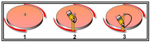
A moving mass travels in a straight line until acted on by some outside force. However, if one views the moving mass from a rotating platform (such as the Earth) the path of the moving mass relative to this platform appears to be deflected or curved. As an illustration consider a turntable (figure above). Draw a straight line from the center to the outer edge of the turntable. The pencil will have traveled in a straight line. However, if the turntable is stopped it is apparent that the line spirals outward from the center. To the viewer on the turntable some apparent force deflected the pencil to the right. This force deflects the wind to the right in the Northern Hemisphere and left in the Southern Hemisphere.
Finally, there is friction between the wind and the terrain surface. This slows the wind, and the rougher the terrain the greater the frictional effect. Also, the stronger the wind speed the greater the friction. This frictional drag of the ground normally decreases with height, and becomes insignificant above the lowest few thousand feet or so. In the atmosphere above the friction layer only the PGF and Coriolis Force affect the horizontal motion of the air.
Temperature
One of the most basic metrics used to describe the atmosphere is temperature. Heat is the total kinetic energy of the atoms and molecules composing a substance. Temperature is the numerical value representing the average kinetic energy of the atoms and molecules within matter, and a higher temperature indicates a higher average kinetic energy (and lower the the opposite). Temperature is an indicator of the internal energy of air.
Heat transfer is energy transfer such as a consequence of a temperature difference. When an object of fluid is at a different temperature than its surroundings heat transfer occurs. This transfer continues until the object/fluid and its surroundings reach equilibrium.
The heat source for the Earth is the Sun, and energy from the Sun is transferred to the Earth’s surface. There are three ways heat is transferred.
| Radiation |
Standing in front of a fireplace or near a campfire is an example of radiation. The side of your body nearest the fire warms, while your other side remains unaffected by the heat. Although you are surrounded by air, the air has nothing to do with this type of heat transfer. Similarly, the Sun radiates heat to the Earth. |
| Conduction |
This is the transfer of energy by molecular activity from one substance to another in contact, or through, another substance. Heat always flows from the warmer substance to the cooler substance. Therefore the warmer substance cools and loses energy while the cooler substance warms and gains energy. |
| Convection |
This is the transport of energy within a fluid, such as air or water, via motions of the fluid itself. Water boiling in a pot is an example of convection. Because air is actually a poor thermal conductor convection plays a vital role in the Earth’s atmospheric heat transfer process. |
Water is much more resistant to heat transfer than land. It warms up and cools down more slowly than land, and heps moderate nearby air temperature. This is why islands and ocean cities experience smaller seasonal temperature variations than inland locations.
Temperature in the atmosphere generally decreases at an average rate of 2 degrees per 1,000 feet of altitude gain. But, in the tropopause sometimes temperature remains constant or even increases with altitude changes. This can create an isothermal layer where the temperature remains constant with height. A temperature inversion is a layer in which the temperature increases with altitude, and it can be an inversion starting at the surface (a "surface based inversion") or not (an "inversion aloft"). One key characteristic of an inversion is that it is extremely stable so that very little turbulence can occur within it.
Moisture/Precipitation
There are a few key ingredients needed to create visible moisture and/or precipitation in the atmosphere. They are the presence of water vapor in the air, and lifting action which condenses that vapor into clouds. To produce precipitation there needs to be a growth process that allows cold droplets to grow large and heavy enough to fall as precipitation.
All clouds contain water, but only some produce precipitation. This is because cloud droplets and/or ice crystals are too small and light to fall to the ground as precipitation. There are two processes which allow cloud droplets to grow large enough to reach the ground as precipitation.
One is collision-coalescence (warm rain process) where collisions occur between cloud droplets of varying size and different fall speeds, sticking together or coalescing to form larger drops. Finally the drops become too large to be suspended in the air and fall to the ground as rain. This is the primary mechanism in warm tropical air masses where the freezing level is high.
Another process is called the ice crystal process which occur in colder clouds when both ice crystals and water droplets are present. In this situation it is easier for water vapor to deposit directly onto the ice crystals. The crystals eventually become heavy enough to fall. If it is cold near the surface it may snow, otherwise the crystals may melt to rain. This is thought to be the primary mechanism in mid and high latitudes.
The vertical distribution of temperature will often determine the type of precipitation that occurs at the surface. There are four different types of precipitation. They are:
| Snow |
This occurs when the temperature remains below freezing throughout the entire depth of the atmosphere. |
| Ice Pellets |
This occurs when there is a shallow layer aloft with above freezing temperatures and then a deep layer of below freezing air based at the surface. As the snow falls into the shallow layer of warm air the snowflakes partially melt. As the precipitation re-enters the air that is below freezing it refreezes into ice pellets. |
| Freezing Rain |
This occurs when there is a deep layer aloft with above freezing temperatures, and a shallow layer of below freezing air at the surface. The precipitation can start as either rain or snow, but becomes rain in the warm layer. The rain falls back into below freezing air but since the depth is shallow the rain does not have time to freeze into ice pellets. The drops freeze upon contact with the ground or exposed objects |
| Rain |
This occurs when there is a deep layer of above freezing air based at the surface. Any frozen precipitation that enters this layer melts before reaching the surface. |
Weather System Formation (Air Masses & Fronts)
An air mass is a large body of air with generally uniform temperature and humidity. The area from which an air mass originates is called a source region. These source regions range from extensive snow-covered polar areas to deserts to tropical oceans. The longer an air mass stays over its source region the more likely it will acquire the properties of the surface below.
These air masses are classified according to temperature and moisture properties of the source region. The temperature properties are roughly divided into three different types. One is arctic, which is an extremely deep cold air mass which develops mostly in winter over arctic surfaces of ice and snow. Another is polar which is a mass of relatively shallow cool to cold air which develops over high latitudes. The last is tropical which is a warm to hot air mass that develops over low latitudes. The moisture categorizations are continental, which is a dry air mass that develops over land, and maritime, a moist air mass that develops over water.
These different temperature and moisture types can be combined in various ways to result in the following characteristic air masses.
Continental Arctic |
Cold, Dry |
Continental Polar |
Cold, Dry |
Continental Tropical |
Hot, Dry |
Maritime Polar |
Cool, Moist |
Maritime Tropical |
Warm, Moist |
Maritime Arctic seldom, if ever, forms |
|
As air masses move around the Earth they can acquire different attributes. For instance, in the winger an arctic air mass (cold and dry) can move over the ocean picking up warmth and moisture from the warmer ocean, and become a maritime polar air mass.
Air masses can control weather for a relatively long time period, ranging from days to months. Most weather occurs along the periphery of these air masses at boundaries called "fronts". A front is a boundary or transition zone between two air masses. These fronts are classified by which type of air mass (col or warm) is replacing the other.
Fronts are usually detectable at the surface in a number of ways. There can be significant temperature change gradients. The winds usually converge. And the pressure typically decreases as a front approaches and increases afterward.
Fronts do not only exist at the surface, but they have a vertical structure as well. Cold fronts have a steep slope, and the warm air is forced up abruptly. If the warm rising air is unstable this often leads to a narrow band of showers and thunderstorms along, or just ahead of, the front. In contrast warm fronts have a gentle slope so the warm air rising along the frontal surface is gradual. This favors the development of widespread layered or stratiform cloudiness and precipitation along, and ahead of, the front if the warm rising air is stable. Stationary frontal slopes can vary, but clouds and precipitation would still form in the warm rising air along the front.
Cold fronts typically move faster than warm fronts, so in time they catch up to warm fronts. As the two fronts merge an occluded front forms. The cold are undercuts the retreating cooler air mass associated with the warm front, further lifting the already rising warm air. Clouds and precipitation can occur in the areas of frontal lift along, ahead of, and behind the surface position of an occluded front.
Clouds
The part of the atmosphere in which clouds are usually present has been divided into three levels: High, Middle, and Low. In each level the clouds may be divided by type.
| Cirrus |
This is a cloud with detached cirriform elements on the form of white, delicate filaments of white patches, or narrow bands. Many of the ice crystal particles are sufficiently large to acquire appreciable speed of fall; therefore, the clouds often trail downward in well-defined wisps called mares’ tails. Cirrus clouds in themselves have little effect on aircraft and contain no significant icing or turbulence. |
| Cirrocumulus |
This is a cirriform type appearing as a thin, white patch, sheet, or layer of cloud without shading, and is composed of very small elements in the form of grains, ripples, etc. They may be composed of highly super cooled water droplets, as well as small ice crystals, or a mix of both. Pilots can expect some turbulence and icing. |
| Cirrostratus |
These clouds appear as a whiteish veil, usually fibrous but sometimes smooth, that may totally cover the sky, and that often produces halo phenomena. They may be so thin and transparent as to render it nearly indiscernible. The existence of a halo around the sun or moon may be the only revealing feature. They are composed primarily of ice crystals and contain little, if any icing and no turbulence. |
| Altocumulus |
These are white and/or grey in color, that occurs as a layer or patch with a wave aspect, the elements of which appear as laminae, rounded masses, rolls, etc. Small liquid water droplets compose the major part of the composition of altocumulus. This results in sharp outline and small internal visibility. At very low temperatures ice crystals may form. Pilots can expect some turbulence and small amounts of icing. |
| Altocumulus Lenticularis |
These are commonly known as Altocumulus Standing Lenticular and they are an orographic (of or relating to mountains) type of cloud. They often appear to be dissolving in some places and forming in others. They often form in patches in the shape of almonds or wave clouds which is caused by wave motions in the atmosphere, and are frequently seen in mountainous or hilly areas. The cloud elements form at the windward edge of the cloud and are carried to the downwind edge where they evaporate. The cloud as a whole is usually stationary or slow moving. The ASCL clouds indicate the position of the wave crests but do not necessarily give an indication of the intensity of turbulence or strength of updrafts and downdrafts. A well-defined wave may be visible in weak updrafts where there is an adequate supply of moisture, but may not be visible when the environment is very dry, even if the wave is intense. |
| Altostratus |
This is a cloud type in the form of a gray or bluish sheet or layer of striated, fibrous, or uniform appearance. It very often totally covers the sky and may cover an area of several thousand square miles. The layer has parts thin enough to reveal the position of the sun and if can have irregularly shaped and spaced gaps and rifts. Pilots can expect little or no turbulence, but light to moderate icing in the super cooled water regions. Within the large vertical extent of the cloud, very distinguished layers exist:
|
| Nimbostratus |
This is a gray cloud layer, often dark, rendered diffuse by more of less continuously falling rain, snow, ice pellets, etc. which in most cases reaches the ground. Not accompanied by lightning, thunder, or hail. Composed of suspended water droplets, sometimes super cooled, and of failing raindrops and/or snow crystals or snowflakes. Nimbostratus has no well-defined base, but rather a deep zone of visibility attenuation. Frequently a false base may occur where snow melts into rain. It is officially classified as a middle cloud, although it may merge into very low stratus or stratocumulus. It produces very little turbulence, but can pose a serious icing problem if temperatures are near or below freezing. |
| Cumulus & Towering Cumulus |
These are individual, detached elements that are generally dense and possess sharp, non-fibrous outlines. These elements develop vertically, appearing as rising mounds, domes or towers, the upper parts of which often resemble cauliflower. The sunlit parts are brilliant white, while their bases are relatively dark and nearly horizontal. If precipitation occurs, it is usually of a showery nature. For cumulus with little vertical development, pilots can expect some turbulence and no significant icing. However, for towering cumulus pilots can expect very strong turbulence and some clear icing above the freezing level (where temperatures are negative). Towering cumulonimbus is also referred to as the first stage of a thunderstorm. |
| Stratocumulus |
These clouds are redominantly stratiform, in the form of a gray and/or whiteish layer or patch, which nearly always has dark parts and is non-fibrous (except for virga). It elements are rounded, roll-shaped, etc.; they may or may not be merged, and usually are arranged in orderly groups, lines, or undulations, giving the appearance of a simple wave system. The Stratocumulus cloud is composed of small water droplets, sometimes accompanied by larger droplets, soft hail, and (rarely) by snowflakes. The highest liquid content is in the tops of the clouds where the icing threat is the greatest, if cold enough. Virga may form under the cloud, particularly at low temperatures. Precipitations rarely occurs. Pilots can expect some turbulence and possible freezing at subfreezing temperatures. Ceiling and visibility and usually better with low stratus. |
| Stratus |
This is a cloud type in the form of a gray layer with a fairly uniform base. Stratus does not usually produce precipitation, but when it does occur, it is in the form of minute particles, such as drizzle, ice crystals, or snow grains. The composition of stratus is quite uniform, usually of fairly widely dispersed water droplets, and at lower temperatures, of ice crystals (much less common). Stratus produces little or no turbulence, but temperatures near or below freezing can create hazardous icing conditions. |
| Cumulonimbus |
This is an exceptionally dense and vertically developed cloud type, occurring either as isolated clouds or as a line or wall of clouds with separated upper portions. These clouds appear as mountains or huge towers, at least the par of the upper portions of which are usually smooth, fibrous, or striated, and almost flattened as it approaches the tropopause. This part often spreads out in the form of an anvil or vast plume. Under the base, which is often very dark, there frequently exist virga, precipitation, and low, ragged clouds. The precipitation is often heavy and always of a showery nature. The usual occurrence of lightning and thunder within or form this cloud leads to its popular names: thundercloud, thunderhead, and thunderstorm. These are composed of water droplets and ice crystals. It also contains large water drops, snowflakes, snow pellets, and sometimes hail. The liquid water forms may be substantially super cooled. Cumulonimbus contains nearly the entire spectrum of flying hazards, including extreme turbulence. |
Turbulence
Turbulence is caused by convective currents, obstructions in the wind flow, and wind shear.
| Convective |
This turbulence stems from turbulent vertical motions that result from convective currents and the subsequent rising and sinking of air. For every rising there is a compensating downward current. The presence of billowy cumuliform clouds, usually seen overland during sunny afternoons, are signposts in the sky indicating convective turbulence. A pilot can expect turbulence beneath or in the clouds, though when air is too dry for cumuliform clouds convective currents can still be active. In this situation pilots have no indication of their presences. |
| Mechanical |
This turbulence is caused by obstructions to the wind flow such as trees, buildings, mountains, and so on. Obstructions to the wind flow disrupt the smooth wind into a complex snarl of eddies. One form of mechanical turbulence are mountian waves. When stable air flow passes over a mountain or ridge developing waves above an downwind of mountains. These can extend 600 miles or more downwind and (amazingly enough) vertically up to 200,000 feet and higher! Mountain waves often produce violent downdrafts on the immediate leeward side of the mountains, and if the air is moist enough cap clouds, cirrocumulus standing lenticular, altocumulus standing lenticular, and rotor clouds are a clear sign of mountain wave. |
| Wind Shear |
This is turbulence generated by a rate of change in wind direction and/or wind speed per unit distance and ma be associated with either a wind shift or wind speed gradient at any level in the atmosphere. One source of wind shear is a termperature inversion. Strong winds can develop across temperature inversion layers which can generate turbulence. Another phenomenon is clear air turbulence. This is a higher altitude turbulence in cloud free regions associated with wind shear, particularly between the core of a jet stream and the surrounding air. |
Thunderstorms and Microbursts
The ingredients of a thunderstorm are sufficient water vapor, unstable air, and a lifting mechanism. The water content is often measured using dew point, and must be present to create unstable air. Virtually all showers and thunderstorms form in an air mass that is classified as conditionally unstable.
A lifting mechanism is required in conditionally unstable air to release the instability. These mechanisms can include converging winds around surface lows and troughs, fronts, upslope flow, drylines, outflow boundaries generated by prior storms, and local winds such as sea breeze, lake breeze, land breeze, and valley breeze circulations.
Thunderstorms progress through a lifecycle, starting as a towering cumulus, moving to a mature stage, then into a dissipating stage. The towering cumulus is formed as a strong convective updraft. The updraft is a bubble of warm rising air concentrated near the top of the cloud which leaves a cloudy trail in its wake. The cell transitions to the mature stage when precipitation reaches the surface. Precipitation descends through the cloud and drags adjacent air downward, creating a strong downdraft alongside the updraft. The downdraft spreads out along the surface as a mass of cool, gusty air. The dissipating stage is marked by a strong downdraft embedded within the area of precipitation. Subsiding air replaces the updraft throughout the cloud, effectively cutting off the supply of moisture provided by the updraft. Precipitation tapers off and ends. The convective cloud gradually vaporizes from below.
There are three broad types of thunderstorms. The single cell, the multicell, and the supercell. The single cell consists of only one cell. Easily circumnavigated, except at night or when embedded in other clouds. Single cell thunderstorms are rare; almost all are multicell.
The multicell thunderstorm consists of a cluster of cells at various stages of their life cycle. As the first cell matures, it is carried downwind, and a new cell forms upwind to take its place. New cells will continue to form as long as the ingredients exist. These can be more difficult to circumnavigate since a line of thunderstorms can extend for hundreds of miles. New cells continually reform at the leading edge and the line can persist for many hours as long as the necessary ingredients exist. These are often too high to fly over, too long to fly around and too dangerous to fly under (the storms in the line can also be supercells).
The supercell storm is a dangerous convective storm that consists of primarily a single, quasi-steady rotating updraft that persists for an extended period of time. It has a very organized internal structure that enables it to produce especially dangerous weather for pilots who encounter them (updrafts may reach 9,000 fpm). A supercell may persist for hours; new cells will continue to form as long as the necessary ingredients exist.
The hazards of a thunderstorm include lightning, adverse wind, downburst, turbulence, icing, hail, rapid altimeter changes, static electricity, and tornadoes. Just about every flight hazard that might be imagined are contained within thunderstorms.
Icing and Freezing Levels
Icing is the development and accumulation of ice on the airframe. Structural icing degrades engine performance, and can destroy the smooth flow of air over the wing increasing drag while decreasing the ability to create lift. An insidious cycle develops where as power is added to compensate for the added drag the nose is lifted to maintain altitude, and the angle of attack increases. This higher angle of attack allows the fuselage and wings to collect even more ice, thus requiring more power. It can develop as a vicious cycle.
Wind tunnel and flight tests have shown that ice accumulations no thicker than a piece of coarse sandpaper can reduce lift by 30% and increase drag by 40%. Larger accretions can reduce lift even more and increase drag by 80% or more. Due to the ice aircraft may stall at a much higher airspeed and lower angle of attack than is normally the case. The actual weight of the ice on the airframe is insignificant when compared to the airflow disruption caused.
Icing is categorized into two broad categories: clear and rime icing.
Rime icing is rough, milky, and opaque ice formed by the instantaneous freezing of small supercooled water droplets after they strike the aircraft. Rime icing formation favors colder temperatures, lower liquid water content, and small droplets. It grows when droplets rapidly freeze upon striking the aircraft. The rapid freezing traps air and forms a porous, brittle, opaque, and milky colored ice.
Clear icing is a glossy, clear, or translucent ice formed by relatively slow freezing of large supercooled water droplets. Clear icing conditions exist more often in an environment with warmer temperatures, higher liquid water contents, and larger droplets. Clear ice forms when only a small portion of the drop freezes immediately while the remaining unfrozen portion flows or smears over the aircraft surface and gradually freezes. Clear ice is more hazardous than rime ice due to the following factors.
-
It tends to disrupt airflow considerably more than rime icing
-
It is clear and more difficult to see and therefore can be difficult to recognize
-
It is difficult to remove since it can spread beyond the deicing/anti-icing equipment’s capabilities
Mixed icing is, somewhat obviously, a mixture of clear and rime ice. Due to the presence of clear ice it presents much the same hazards as clear icing.
Pilots should be alert for icing any time the temperature approaches 0 degrees Celsius, and visible moisture is present. When the moisture is carried above the freezing level water becomes supercooled. This supercooled water freezes upon impact with the airframe.
When the temperature cools to about -15 degrees C, much of the remaining water vapor sublimates as ice crystals. Above this level, the amount of supercooled water decreases. Clear icing can occur at any level above the freezing level, but at high levels, icing from smaller droplets may be rime or mixed rime and clear ice. The abundance of large, supercooled water droplets makes clear icing very rapid between 0 and -15 degrees C.
Fog
For is a visible aggregate of minute water droplets that are based at the surface and reduce visibility to less than 5/8 stature mile. Fog differs from cloud only in that it’s base must be at the surface, while clouds are above the surface. There are various types of fog, generally depending upon how the fog is formed.
This type of fog is produced over a land area when radiational cooling reduces the air temperature below its dew point. Radiation fog is generally a nighttime occurrence and often does not dissipate until after sunrise. Terrestrial radiation cools the ground, the ground cools the air and when the air reaches its dew point, fog forms. Factors favoring formation: Shallow surface layer of relatively moist air beneath a dry layer, Clear skies, and Light surface winds. Radiation fog is restricted to land because water surfaces cool little from nighttime radiation. It is shallow when wind is calm. Winds up to about 5 knots mix the air slightly and tend to deepen the fog by spreading the cooling through a deeper layer. Stronger winds disperse the fog or mix the air through a still deeper layer with stratus clouds forming at the top of the mixing layer. Ground fog usually burns off rapidly after sunrise. Other radiation fog generally clears before noon (unless clouds move in over the fog).
This type of fog forms when moist air moves over a colder surface, and the subsequent cooling of that air to below its dew point. This is most common along coastal areas, but often moves deep in continental areas. Advection fog deepens as wind speed increases up to 15 knots; winds much stronger than 15 knots lifts the fog into a layer of low stratus or stratocumulus clouds. The west coast of the US is quite vulnerable to advection fog which frequently forms offshore as a result of cold water and then is carried inland by the wind. It can remain for weeks, advancing over the land during the night and retreating back over the water the next morning. A pilot will notice little difference flying over advection and radiation fog
This type of fog forms as a result of moist, stable air being adiabatically cooled to or below its dewpoint as it moves up sloping terrain. Wind speeds of 5-15 knots are most favorable; stronger winds tend to lift the fog into a low layer of stratus clouds. Common along the eastern slopes of the Rockies, and somewhat less frequent east of the Appalachians. It is often quite dense and extends to high altitudes.
When warm, moist air is lifted over a front, clouds, and precipitation may form. If the cold air below is near its dewpoint, evaporation may saturate the cold air and form fog. The result is more or less a continuous zone of condensed water droplets reaching from the ground up through the clouds. This is most commonly associated with warm fronts, but can occur with others as well. It can be quite dense and continue for an extended period of time.
This type of fog forms when very cold air moves across relatively warm water, enough moisture may evaporate from the water surface to produce saturation. As the rising water vapor meets the cold air, it immediately re-condenses and rises with the air being warmed from below. Because the air is destabilized, fog appears as rising streamers that resemble steam. Steam fog is often very shallow; as the steam rises, it re-evaporates in the unsaturated air above. Pilots should expect convective turbulence flying through it.
Frost
On cool, clear nights, the temperature of the ground and objects on the surface can cause temperatures of the surrounding air to drop below the dew point. When this occurs, the moisture in the air condenses and deposits itself on the ground, buildings, and other objects like aircraft. The moisture is dew, but if the temperature is below freezing, the moisture is deposited in the form of frost. While dew poses no threat to aircraft, frost poses a definite flight safety hazard. It disrupts the smooth airflow over the wing and can drastically reduce the production of lift. It also increases drag, which when combined with lowered lift production, can adversely affect the ability to takeoff. An aircraft must be thoroughly cleaned and free of frost prior to beginning a flight.
Importance of a Thorough Weather Briefing
Weather impacts safety of flight so significantly that obtaining a clear understanding of all weather related to a flight is essential. Referencing FAR 91.103, the pilot is required to become familiar with the weather reports and forecasts. A weather briefing is the 1st step in determining if the flight can be conducted safely and where and when problems may occur. Weather can be dangerous, but if you know what to expect, weather briefings can alert the pilot to hazards.
Weather Information Sources
There are numerous sources if weather information. Some of the most commonly used sources are discussed in this section.
For general awareness of the overall weather a pilot can use the Transcribed Information Briefing Service (TIBS). This is a continuous telephone recording of meteorological/aeronautical information available at 1-800-4TIBS-WX. This provides area and route briefings, airspace procedures, and special announcements. Additionally there is the Transcribed Weather Broadcast (TWEB), which is a weather report transmitted continuously over a selected navaid. The availability of this broadcast is indicated by a "T" in the upper right corner of the navaid ID box on a sectional. It provides route oriented information such as a route forecast, foecast outlook, winds aloft, and other selected weather. It is valid for an area within 50nm of the FSS, and valid for 12 hours. It is updated four times a day.
For a detailed briefing for a specific flight, there are other services that can be used. In no specific order of utility, they are :
| FSS |
This is Flight Service, and is the primary source for preflight weather. It is available at the well known phone number 1-800-WX-BRIEF. Flight is now also available at https://www.1800wxbrief.com/. |
| DUAT(S) |
This is an older weather service which has recently been discontinued. It was an online service and has been superseded by the service available now at https://www.1800wxbrief.com/. |
| NWS |
This is the national weather service. It can be accessed at https://www.weather.gov/. |
| SWSL |
This is the Supplemental Weather Service Location. (Find more details on this, and if you can’t delete it!) |
Previously there was a service called Flight Watch (aka: EFAS) which was available on the frequency 122.0, but this service has been discontinued. Either use the flight service common frequency of 122.2, or other area remote communications outlets, for EFAS type information. This can provide weather information specific to the route, type of flight, and cruising altitude.
It is also possible to get weather information in flight by tuning a HIWAS frequency. This is denoted by an "H" in the upper right corner of the navaid identification box. It can provide information regarding hazardous weather which includes AIRMETs, SIGMETs, Convective SIGMETs, and urgent PIREPs.
In-Flight Weather Advisories
There are various in-flight weather advisories that may be made available to the pilot. They are noted here :
| AIRMET (WA) |
These are issued every 6 hours, with intermediate updates as needed for a particular area forecast region. The information is of interest to all aircraft, but the weather section concerns phenomena dangerous specifically to light aircraft. There are three types, which are DIERRA (denotes IFR and mountain obscurement), TANGO (denotes turbulence, strong surface winds, and low-level wind shear), and ZULU (denotes icing and freezing levels). |
| SIGMET (WS) |
This is an in-flight advisory concerning non-convective weather that is potentially hazardous ot all aircraft. It can include severe icing, extreme turbulence, and clear air turbulence (CAT) not associated with thunderstorms, dist/sand storms lowering visibility to less than three miles, and volcanic ash. These are unscheduled forecasts valid for 4 hours (with hurricane SIGMETs being valid for 6 hours). |
| Convective SIGMET (WST) |
This is a weather advisory issued for hazardous convective weather that affects the safety of every flight. They are issued for a severe thunderstorm (i.e. one with surface winds greater than 50 knots, hail at the surface >= 3/4 inch in diameter, or tornadoes), embedded thunderstorms, a line of thunderstorms, or thunderstorms with heavy or greater precipitation affecting 40% or more of a 3,000 square foot or greater area. |
| PIREP |
This is a pilot generated report concerning meteorological phenomena encountered in flight. These are important because aircraft in flight are the only way to observe cloud tops, icing, and turbulence. PIREPs fill in the gaps between reporting stations. |
Recognizing Weather Hazards
Hazards can be recognized through proper interpretation of aviation weather charts, reports, etc. These would include Area Forecasts, WST, WS, WA, and Significant Weather Prognostic charts. Also, utilizing weather information resources (LLWAS, PIREPS, Convective Outlook, METARs, etc.) will allow hazards to be recognized.
Go/No Go Decision
The go/no go decision includes a number of possible factors, with one significant component being the weather. The decision must be made as to whether the pilot can handle the aircraft and conditions expected to be encountered during the flight. Certain conditions may warrant an automatic no-go decision. These might include the following.
-
Thunderstorms of any kind, especially embedded
-
Fast-moving fronts or squall lines
-
Moderate or greater turbulence
-
Icing
-
Fog, or other visual obscuration
In addition to weather other factors can drive a go/no-go decision. The physical and mental condition of the pilot is important. If the pilot is sick, depressed, upset, or tired those conditions may affect the pilot’s ability to handle the demands of the flight. Use the IMSAFE checklist to help evaluate.
Evaluate the pilot’s recent flight experience, as well. Don’t go beyond the pilot’s or the aircraft’s current capabilities. For instance, is the pilot comfortable dealing with MVFR conditions if they haven not flown in some time?
Flying is a continual decision making process throughout any flight. Weather and other circumstances evolve with time, so divert or discontinue a flight enroute if conditions warrant.
Conclusion
It is very important to be able to interpret and make a Go/No Go decision based on the information attained. A safe flight begins with a thorough weather briefing to ensure the pilot understands the meteorological factors that may affect the flight.
ACS Requirements
To determine that the applicant exhibits instructional knowledge of the elements related to weather information by describing:
-
Importance of a thorough preflight weather briefing.
-
Various means and sources of obtaining weather information.
-
Use of real-time weather reports, forecasts, and charts for developing scenario-based training.
-
In-flight weather advisories.
-
Recognition of aviation weather hazards to include wind shear.
-
Factors to be considered in making a “go/no-go” decision.