Lesson Overview
To develop knowledge of the elements related to the National Airspace System.
References : 14 CFR Part 71, 14 CFR Part 91, Airmans Information Manual, Navigational Charts
| Key Elements |
|
| Elements |
|
| Schedule |
|
| Equipment |
|
| IP Actions |
|
| SP Actions |
|
| Completion Standards |
The student displays the ability to differentiate between the different types of airspace and their respective weather minimums and requirements. |
Instructor Notes
| Attention |
Each type of airspace is like a different country. Each type of airspace has its own controllers or rulers, its own rules for those in their ‘territory,’ and its own benefits or services which are provided to those within its borders. Borders are drawn and there are requirements and permission necessary to enter certain airspaces (e.g. Passport). |
| Overview |
Review Objectives and Elements/Key ideas |
| What |
Airspace is defined as, “the portion of the atmosphere above a particular land area, especially above a nation.” The atmosphere above the United States is divided into several sectors, or classes and in each different airspace class, specific rules apply. |
| Why |
Different airspaces have been defined to efficiently manage the large amount of air traffic that traverses the sky each day. In order to fly from place to place a pilot must know the rules and requirements regarding airspace. |
Lesson Details
The National Airspace System (NAS) is the airspace, navigation facilities and airports of the United States along with their associated information, services, rules, regulations, policies, procedures, personnel and equipment. It includes components shared jointly with the military. It is one of the most complex aviation systems in the world and services air travel in the United States and over large portions of the world’s oceans.
Airspace Categories
Broadly speaking, the NAS is divided into various categories of airspace, depending upon the needs in the areas included. The different categories of airspace have different operating rules, as well as different certification and equipment requirements.
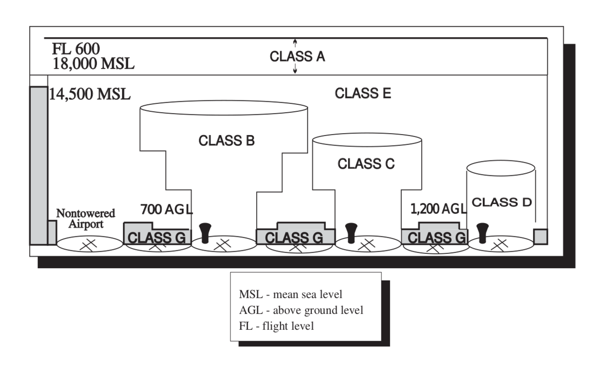
Class G
This class of airspace is uncontrolled airspace, and is any airspace which has NOT been designated either Class A, B, C, D or E airspace. It extends from the surface to the base of the overlaying class E airspace. Although ATC has no authority or responsibility to control traffic in Glass G airspace, there are still VFR minimums which apply.
Class E
This airspace is all controlled airspace which is NOT designated as Class A, B, C, or D airspace. Class E comprises the bulk of all airspace in the United States. Unless otherwise indicated, this airspace starts at 14,500 feet MSL and continues up to (but not including) Class A airspace (18,000 feet MSL). However over most of the eastern portion of the United States Class E is depicted as extending down to 1,200 feet AGL, and in some instances down to 700 feet AGL. The extension of Class E to 700 feet AGL is around some airports Class E airports to provide a transition zone for instrument operations and this lower limit is depicted on sectional charts. Mountainous terrain may have a floor above 1,200 feet AGL. Airways are also in Class E airspace, and are usually 8 nm wide (4 nm on each side of the centerline).
No clearance is required to opearte in Class E airspace. VFR visibility and cloud clearance requirements are the same as for Class C and D airspaces when below 10,000 feet MSL. Above 10,000 ft MSL, the visibility requirement is extended to 5 miles and the cloud clearance requirement is extended to 1,000 feet below clouds, 1,000 feet above, and 1 mile laterally. The primary motivation for the higher limits above 10,000 feet MSL are due to the higher speeds permitted above that altitude. It should also be noted that all airspace above FL600 is also Class E airspace.
In Class E airspace a transponder is required above 10,000 feet MSL, within 30 nm of a Class B airspace primary airport, within 10 miles of certain designated airports, and when flying into/within/across the ADIZ. Airspeed is limited to no more than 250 knots below 10,000 feet MSL. Airspeed is also limited to 200 knots below 2,500 feet AGL and within 4 nm of the primary Class C/D airport. In airspace underlying Class B, or in a VFR corridor through Class B airspeed is limited to 200 knots.
The minimum pilot qualifications for operation in Class E airspace is a student pilot certificate. There are no communications requirements to operate in Class E airspace, but ATC traffic advisory services can be requested on a workload permitting basis.
Class D
This airspace is typically around airports with functioning control towers, and extend from the airport surface to 2,500 feet above the airport elevation. They normally have a radius of 4 nm, but this can be changed depending upon needs. At airports with a part-time control tower, the airspace is Class D only when the tower is operational, otherwise it is Class E airspace.
No special pilot certification is needed (i.e. student pilots are permitted) and a two-way radio is required. The pilot must establish two-way radio communications with the tower prior to entering the airspace.
Class C
This airspace is established around busier airports which have an operational control tower and are serviced by radar approach control. The airspace is often described as looking like an "upside down wedding cake", with the central core consisting of a 5nm radius extending from the surface to 4,000 feet above airport elevation, and an outer airspace ring consisting of a 10nm radius extending from 1,200 feet to 4,000 feet above airport elevation. However, in some circumstances (see KAVL) the airspace shape can be modified as needed for the airport’s specific circumstances.
No special pilot certification is needed (i.e. student pilots are permitted) but there are minimum equipment requirements. A two-way radio and an operable radar beacon transponder with automatic altitude reporting equipment (Mode C) are required. Note that as of January 2020 the equipment mandate will extend to requiring ADS-B Out capability in the aircraft. The pilot must establish two-way radio communications with ATC prior to entering the airspace.
Class B
This airspace is established around the busiest of all airports in the United States. These busy airports are serviced by approach control radar, have control towers, and classically get their designation as Class B due to the number of IFR operations performed and number of passengers which transit the airport in a given year. The shape of the airspace also often resembles an "upside down wedding cake" but is frequently tailored to the specific needs of the airport. This airspace is designed to contain all instrument operations once the airspace has been entered by participating aircraft.
In this airspace a private pilot certificate must be held by the pilot, with the one exception being a student pilot who has an endorsement from their instructor for operating in the airspace (14 CFR 61.95). This FAR is generally interpreted to mean "have an instructor’s endorsement for having been properly trained in that specific class B space". For VFR operations an ATC clearance must be issued before entering the Class B airspace. Equipment requirements are a two-way radio, and an operable 4096-code radar beacon transponder. For IFR operations the aircraft must also have a VOR/TACAN receiver, and must have altitude reporting equipment. There may also be a 30nm "mode C veil" around a primary Class B airport. This veil extends from the surface to 10,000 feet MSL mandating an altitude reporting Mode C transponder unless the aircraft is certified without an engine-driven electrical system and it operates outside the class B and below the ceiling of the class B and below 10,000 feet MSL.
VFR flights operating in class B airspace must have three miles of visibility and must remain clear of clouds (no minimum distance).
It is often the case that "special VFR" operations are prohibited within Class B airspace. Consult the chart supplement for details regarding a given airport.
Class A
This is the airspace above 10,000 feet MSL, and below FL600 including the airspace overlying the waters within 12nm of the coast of the 48 contiguous states and Alaska. Unless otherwise authorized all operations in this airspace are conducted under IFR.
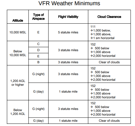
Weather and Visibility Minimums
This table summarizes the weather minimums for VFR flight in the various different airspaces, at different altitudes, and during the day versus night.
On first examination this looks complex, but the decision tree can be boiled down to the following flowchart. In the following flowchart the nomenclature of D-XXX is such that the D is a digit indicating visibility in statute miles, and the XXX indicates the cloud clearance. It is encoded such that 152 means 1,000 feet above, 500 feet below, and 2,000 feet horizontal clearance.
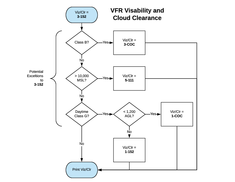
As you traverse the set of decisions, whenever a new Viz/Clr value is set, it is the one you retain until some other condition superceedes it.
Special Use Airspace
There are other segments of airspace in the United States which are set aside for special operations, or activities. There are about six different categories of "special use airspace" and in all cases it is due to the desire of the government to control or restrict access for either safety or security reasons.
- Prohibited Areas
-
This is airspace within which the flight of aircraft are not permitted. This sort of airspace is usually established for security or other purposes related to national security. They are published in the Federal Register and are depicted on aeronautical charts.
- Restricted Areas
-
This is airspace where flight is not wholly prohibited, but is subject to restrictions. They generally denote the existence of unusual, often invisible hazards, to aircraft. This can include artillery firing, aerial gunnery, or guided missile operations. An aircraft may not enter a restricted area unless permission has been obtained from the controlling agency. If the restricted area is not active then ATC will permit an aircraft to enter the airspace, and otherwise will ensure that the aircraft avoids the restricted area (when on an IFR flight plan). Restricted areas are depicted on aeronautical charts and are published in the Federal Register.
- Warning Areas
-
This is airspace extending from 3 nm outward from the coast of the US that may be hazardous to non-participating aircraft. Activities in this airspace may be similar to those found in restricted areas. The purpose of these areas is to warn non-participating aircraft of potential dangers. They are depicted on aeronautical charts.
- Military Operation Areas (MOA)
-
This is airspace established for the purpose of separating certain military training activity from IFR traffic. IFR Traffic may be clearned through the MOA if it is not active, otherwise ATC will re-route the IFR traffic. There is no restriction against operating VFR in these areas, though a pilot should remain alert since training activities may include aerobatic and abrupt maneuvers. MOAs are depicted on aeronautical charts.
- Alert Areas
-
This is airspace designated to inform pilots of a high volume of pilot training or other unusual aerial activity. They are depicted on aeronautical charts.
- Controlled Firing Areas
-
This is airspace where certain activities, if not conducted in a controlled environment, could be hazardous to non-participating aircraft. Activities must be suspended when a spotter aircraft, radar, or ground lookouts indicate an aircraft may be approaching the area. There is no need to chart these areas since they do not cause non-participating aircraft to change their course.
Other Airspace
This section discusses various other miscellaneous types of airspace. These vary greatly in nature, but are all designed to aid the orderly and safe flow of traffic in certain areas.
- Airport Advisory Areas
-
This is an area within 10 sm of an airport where a control tower is not operating but where an FSS is located. In this airspace the FSS can provide advisory services to aircraft arriving and departing the area.
- Military Training Routes
-
These are predetermined routes which were developed to allow the military to conduct low-altitude, high-speed training. The routes above 1,500 feet AGL were developed to be flown primarily under IFR, and the routes lower are for VFR flight. They are depicted on sectional charts by the designation IR for instrument, and VR for visual routes.
- Temporary Flight Restrictions (TFRs)
-
These are established for various reasons; protect persons or property in the air or on the surface from an existing or imminent hazard, provide a safe environment for the opeartion of disaster relief aircraft, prevent an unsafe congestion of sightseeing aircraft above an incident or event, protect declared national disasters for humanitarian reasons in Hawaii, protect the President or Vice President or other public figures, or provide a safe environment for space agency operations. These are communicated with an FDC NOTAM, and these NOTAMs will begin with the phrase "FLIGHT RESTRICTIONS" followed by the location of the temporary restriction, effective time period, area defined in statute miles, and the altitudes affected. It is critical that all pilots check for TFRs prior to flight.
- Parachute Jump Areas
-
These are published in the chart supplement (nee AFD). Frequently used jump sites are often depicted on sectional charts.
- Published VFR Routes
-
These are used by VFR pilots to transition around, under, or through some complex airspace. They are often also called "VFR flyway", "VFR corridor", "VFR transition route", and "terminal area VFR route". They are generally found on VFR Terminal Area planning charts.
- Terminal Radar Service Area (TRSA)
-
This airspace is a holdover from the pre-ICAO class system and are in place at roughly 30 airports in the United States. The TRSA was established as part of a program to create Terminal Radar stations at selected airports. While operating in these airspaces, a pilot who chooses to participate will receive radar services, but participation is not required for VFR operations. TRSAs will encompass a primary airport with a class "D" designation and the TRSA will be above other controlled airspace (Typically Class E Airspace) with a typical floor of 700 feet or 1,200 feet AGL (Above Ground Level).
- National Security Area
-
This airspace consists of defined vertical and lateral dimensions established at locations where there is a requirement for increased security and safety of ground facilities. Pilots are requested to voluntarily avoid flying through these depicted areas. When necessary, flight may be temporarily prohibited.
Conclusion
Overview of the differences based on airspace and traffic.
ACS Requirements
To determine that the applicant exhibits instructional knowledge of the elements of the national airspace system by describing:
-
Basic VFR weather minimums—for all classes of airspace.
-
Airspace classes—their operating rules, pilot certification, and airplane equipment requirements for the following:
-
Class A.
-
Class B.
-
Class C.
-
Class D.
-
Class E.
-
Class G.
-
-
Special use airspace (SUA).
-
Temporary flight restrictions (TFR).